Thursday, September 21, 2023

Death Valley National Park: Road Trips from Los Angeles

Death Valley National Park, photo by Armando Ortiz

Death Valley National Park: Road Trips from Los Angeles

By Armando Ortiz


Introduction to Death Valley:

Death Valley National Park is one of the most unique places to visit in the U.S. It is a place where what you think is impossible is possible. Here you discover tiny little animals that continue to survive in the harshest of environments. You also see with your own eyes things that have probably taken decades if not centuries to occur and wonder if it was manmade. It's a place where the salt lands make you rethink the idea of snow capped mountains. It falls within a region that was inhabited by the Shoshone people for many centuries, and who had villages in the area. The Shoshone had adapted to life in the extreme desert. I first heard of this mysterious place from someone who asked me if I’d ever been to the Racetrack Playa. I’d never heard of the place, but after a brief explanation I made the connection with pictures I’d seen growing up. The following is a short description of one of the many itineraries that one may make if you plan to visit Death Valley at some point in your life. After you are done with your visit you will be plotting out your next adventure to the park. 


Route taken and what we saw:

Start your day early and drive to Death Valley National Park. Make sure you have all the necessary camping gear, food, and plenty of water. Before embarking on this journey I had previously bought a portable air compressor, a tool bag, patch kit, a shovel, recovery strap, and plenty of water. These things would be safely packed inside the truck. Being that we were going into the desert we packed sunscreen, long sleeve shirts, pants and a good hat. We took several gallons of water in case anything happened. 

Death Valley National Park, Racetrack Playa, photo by Armando Ortiz
From Los Angeles you take Interstate 5 North to California Highway 14. On this highway the drive might be between two hours to an hour and a half,  which you drive to 395 north to Death Valley. The route that we took was slightly different and off the beaten path. I drove north on the 14 for about an hour till we reached Cantil. Once there, we exited and took the road to the right which is Redrock Randsburg Road. This road then becomes Garlock Road and briefly joins the U.S. Route 395 from which you will make a right onto Searles Station CTF. This section of the drive is about an hour long. 

You stay on this road till you join Trona Road and make a right. This will then take you to State Route 178. Drive on this road for about an hour to an hour and a half and finally you’ll reach 190. On this highway make a right onto it and drive up the ridge and over into Death Valley for about another hour. Since this area is sparsely populated and hardly any buildings, things might seem closer than they really are and mountains that don’t seem to have roads do. Once on the eastern facing side of the range you can take in the vastness of the valley. Let your car coast down, gently applying the brakes when needed.

It will take a few hours of driving to get to Death Valley National Park, but the views there, especially in the Spring are great. You can stop at Stovepipe Wells and have lunch there. We stopped there for a quick bite, ordered burgers. After finishing off our meal we got back on the highway, and headed east. Soon we reached Scotty’s Castle Road, where you will turn left and drive for about thirty minutes. Arrive at the Mesquite Spring Campground, which is a great base for exploring Death Valley. We set up our campsite and resumed our journey. Destination for the day- Racetrack Playa. 

Death Valley National Park, photo by Armando Ortiz
The drive to Racetrack Playa is rough and requires a high-clearance vehicle, like a four wheel drive truck or suv, so make sure you are prepared. The drive is about 50 miles round trip, and can be slow. 20 to 25 mph seems to be the sweet spot. The road is very rocky, but the views and surrounding mountains are amazing. As you reach the entrance to the gravel road, you’ll see signs to Ubehebe Crater. Once on the gravel road, pull to the side, stop your truck or suv and lower your tire pressure. I lowered them to about 28 psi, but later adjusted them a bit more. After this minor tweak, you can continue your journey. 

As you move along you get the feeling of driving both through the mountains of Mars and the backdrop of a Star Wars set. All you hear is rubber rubbing on loose rocks, and the vehicle rocking from left to right. After about an hour of driving, you’ll reach Teakettle Junction. This intersection indicates that you are a few miles away from your destination, which translates into 30 minutes more of driving. At this junction people place their tea kettles with messages inside them for others to read. So, get out, look around, and read some of the messages and get a good laugh. As you approach your destination you'll begin to see it at a distance, a seemingly quiet valley surrounded by rocky hills and mountains. At a distance you might notice a plume of dust might be seen at a distance of a vehicle either coming or going. 

Death Valley National Park, Ubehebe Crater, photo by Armando Ortiz
Once you arrive, take your time to explore the unique “sailing stones” or “moving rocks” that mysteriously move across the dry lake bed. Set aside an hour or two to hike around the playa and to climb the rocks on the island. There you can enjoy the breathtaking views and take plenty of pictures at Racetrack Playa. Marvel at the vastness of the desert landscape and the geological wonders surrounding you.


Death Valley activities and length of time recommendations:

Death Valley National Park, Badwater Basin, photo by Armando Ortiz
After you are done exploring and admiring the mystery of the landscape, get ready for the drive back. It will seem as if you are driving much faster, which is probably because the road will seem more familiar. I reduced the tire pressure a bit more, down to 25 psi, allowing me to drive more comfortably. Getting back on the road I inflated the tires and drove back to our base which was about a 15 minute drive. Once you return to Mesquite Spring Campground you’ll have time to prepare dinner. We decided to make sausages with tomatoes and peppers, a tasty dish when camping. After you are done with dinner enjoy a relaxing evening and admire the sky. It is best if you visit during a time when the moon is waning or waxing because a full moon will block a lot of the stars. If you are lucky the snow capped mountains will seem like they are glowing. Set up a campfire, and spend the evening looking at the sky or talking, sharing stories and enjoying the desert.

The next day we woke up early, packed up and drove to Ubehebe Crater, a volcanic crater located in the northern part of Death Valley. It’s only a few miles from Mesquite Springs Campground. Take a hike around the crater rim or hike down to the bottom of the crater and explore the area. The hike down is easy, but a bit steep. Once at the bottom explore the old muddy caldera, and take a good gulp of water because the hike up can be tough. According to the information there the crater was created after an accumulation of steam caused a giant eruption making the crater. As you return to your starting point the hike will be tough at times because the footing can be loose. You also have the option of hiking around the crater, but we decided to leave that for another time. 

Next, we made a beeline to Badwater Basin, the lowest point in North America with a surreal landscape of salt flats. We drove about seventy miles south, so relax and enjoy the vistas, sunny weather. The valley seems to go on forever. Once you arrive at Badwater take a walk on the salt flats. Take your time and enjoy the vast expanse of the basin. Remember to take pictures. We were lucky to see a contrast between the white salt ground and the snow capped mountains at a distance. The sun's rays were strong, and being that the ground is white the radiating rays feel very strong, so make sure to wear loose clothing that also protects you from the sun. Try to spot the tiny salty fibers that are made within the concave ground you’ll be walking on. The fibers resemble the fine weave of a spider’s web.

After visiting Badwater Basin, we continued our drive along the scenic road north to Artist’s Palette, which is about a 10 mile drive along the baseline of the mountains. This area showcases a stunning array of colorful rock formations due to various minerals present in the soil. Take some short hikes and take some pictures or enjoy the drive through this geological wonderland. Admire the layers of colors that are visible, yellows next to pinks, and copper greens next to blue layers of sage.

As the day came to a close, we drove north to rejoin the 190 once again and there made a left. Here you may fill up on gas or get a quick bite at the local diner. Drive over the mountain ranges and into a valley that if you continue on the highway will take to Olancha, where it connects to the 395 and from there head south. You can also make a left onto the Panamint Valley Road and retrace your drive back to Los Angeles.


Ending and review:

Visiting Death Valley once seems like it isn’t enough. It will get you thinking about the things that you might want to do the next time you go. I’d return again during Spring, and would take a telescope to do some stargazing. I’d also go on one of the longer hikes and explore some of the canyons in the area. There are many ways to enter the park, so I’d consider approaching it from a different direction. In the end, Death Valley makes you appreciate desert environments even more. It makes you realize how big our country is and the endless possibilities that its national parks offer. Visiting this place also leaves you wondering of the many other mysteries and untold stories that this land keeps hidden in its canyons and valleys.


Tuesday, September 12, 2023

Dyad: Free-verse

Dyad

By Armando Ortiz


Dyad of butterflies

dancing in the air,

fluttering orange wings, 

in mid flight with gentle flare.


Dyad of butterflies,

under a summer sun,

floating by as in a song,

to a place unknown. 


Dyad of butterflies,

midday sun is bright,

the light making bare, 

watch how they take flight.


Dyad of butterflies,

coming and going,

with time to spare,

dancing along in midair.


Dyad of butterflies,

rising and falling,

pausing and swimming, 

blown along the air.


Dyad of butterflies,

open and close,

castaways sailing,

on shimmering waves.


Tuesday, September 5, 2023

Bryce Canyon National Park: A Hike into the Layers of Time and Mind

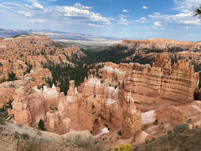
Photo by Armando Ortiz, Bryce Canyon National Park

Bryce Canyon National Park: A Hike into the Layers of Time and Mind

By Armando Ortiz


Bryce Canyon National Park lies on the Colorado Plateau of the Four Corners region of the United States. It is part of a geological area called the Escalante Grand Staircase. This area includes Zion National Park and to the south the Grand Canyon, making it quite remote but also unique in many ways. It's called a staircase because there are different layers of rock and sediment that can be seen from the highest to lowest point, making it a geologist and camper's paradise. In other words, this area’s varying layers of land are exposed and it's like seeing the different layers of a cake that are up to ten thousand feet tall. There are many things one can do in this area like stargaze, camp and hiking of varying difficulties. The highest points of this geological area are found in Bryce Canyon. Bryce Canyon in other words is at the edge of a plateau that is about nine thousand feet above sea level. This men


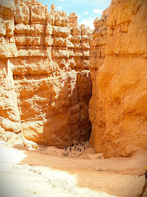
Hiking Bryce Canyon is a preternatural experience. You start your hike at the parking area where you can take several short hikes that follow the edge of Bryce Canyon. These trails offer lots of shade and you can admire the various pine trees that coexist. Hiking down into a canyon you feel like walking down into an orange amphitheater. Monsoon rains will highlight the scents of the trees and bushes as you enter this world. You will be greeted by a pine that has grown in between the clay walls. You’ll look up to see branches extended a few feet above you.


If you let your mind wander you begin to see things that weren’t there before. Kachina figures carved on the mountains seem to stand erect. Mud heads watching along the trail, waiting for you to get distracted. Bear scratches on the giant walls seemed to have been marked by an ancient species. Grottoes of unknown weathered buddhas seem to have been there for hundreds of years, weathered and sunbathed, still standing. Yet, one has to be reminded that we are walking on sacred land.


You start wondering if milarepa was mingling with Paiute shamans. These geological wonders were once places to rest. Its shade provides respite from the sun. Then suddenly a chipmunk races across and to the top causing these delicate walls to crumble. You notice mangled pine roots grabbing on to cliff sides. Their dark and gnarled limbs contrasting the red earth. You suddenly might find yourself in a shaded niche of sorts. A quiet location where the grinding of seeds and medicine took place. Maybe during vision quests the stars were studied from that spot. The spires seem to watch your every move. The sun, whether it be a cloudy day, is strong.


One feels like walking in a labyrinth of tangerine and white pinnacles. Pine tree branches bent, 4 shaped limbs marking the way. You pass through the ruins of a desert palace made of adobe orange and red clay. You begin to wonder if the story of hoodoos is real or not. We stop in between an entrance and rest our bodies from the sun in the cool shade. Take a sip of water, because there isn't any anywhere. The sun bears down on your body making your skin sticky and wet. If it wasn’t for the trail signs we’d be like rodents finding the exit.


Your mind begins to wonder if these earth formations are the ruins of the Anasazi. Entry ways lead you to other openings. Pathways that were once hallways are dead ends. These labyrinths make you dizzy. Maybe the ancients that committed sins are dwelling here and intend to get us lost. There is a pause in the hike, and we look up, the sky is a deep blue, and puffy white clouds indicate flash floods in the distance.


Faces carved by nature and time appear from out of nowhere. Suddenly one of the pillars seems to be wearing a white fedora. Rhinoceros horns make tops of the white fins that outline the ridges within the canyon. The image of the Virgin Mary appears eroded on the cliffs. Maybe it is time to pray to the gods. Your legs get shaky, but it's the heat and the dizzying hike. You follow the people ahead of you hoping they know the way. You wonder if cloud tears had created this site, millennia of thunderstorms passing through, feeding every nook and cranny with water.


Following the path down leads you to the smallest theater in the world, and from there you might discover a weathered diorama to one’s imagination. Maybe if you are lucky you might hear the old song dedicated to the sun. Focus on following the signs and keep track of the distance. When in doubt stand about under the shade, someone is bound to pass by. Again, water is essential on this trail, so take sips as you go. As you begin to reemerge from this mysterious place, turn around, and admire the vastness of the place. Once people called this place home, and found their way out just like we did. You return to the rim of the canyon, and you begin to see more greenery. Walk to your car and look back down at the canyon, you were just down there. 

Photo by Armando Ortiz, Bryce Canyon National Park