Showing posts with label road trips. Show all posts

Sunday, July 30, 2023

Crater Lake National Park: Road Trips from Los Angeles

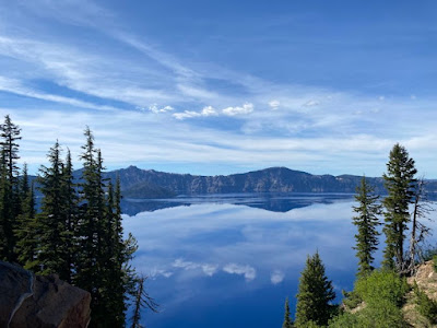
Crater Lake National Park, photo by Yeny Mancia

Crater Lake National Park: Road Trips from Los Angeles

By Armando Ortiz


Crater Lake National Park: Nature’s Geologic Wonder Awaits

Situated in South Central Oregon among pine forests that stretch far and wide lies a breathtaking wonder: Crater Lake National Park. Once a giant volcano that surpassed all others in the American Northwest, this park now offers waterfalls, lakes, rivers and creeks surrounding this ancient caldera. If you’re in search of a National Park adventure that unveils geologic wonders and mysterious lakes, this post is made for you. Let’s delve into what you will and might see and discover if you embark on a trip to this captivating destination.


The Road Trip: Unveiling Nature’s Magic

Driving to Crater Lake is easier than it looks, and the drive promises something magical as you drive through diverse landscapes. Road trips have a certain magic to them that cannot be replicated with air travel. Starting the seven hundred mile road trip from Los Angeles, you take the i-5 freeway north. Soon you’ll be driving through the San Joaquin Valley that’s peppered with agricultural towns and golden rolling hills. As you approach Sacramento there might be some traffic, but soon you continue your drive along what seems to be an endless valley. 

Progressing further north, the landscape begins to change and you see oak trees along the edge of the highway, as you continue on it becomes a mix of oaks and pines. At Redding, pines begin to paint the land a deep green, and this will be a good place to stock up on groceries and gas.

At a distance you’ll begin to see the majestic snow capped Mount Shasta, California’s own version of Mt. Fuji. Once you drive past Weed, CA you will take the 97 which will take you northeast. As you keep driving you’ll see views of Mt Shasta and appreciate its grandeur. Driving through the tiny town of Dorris, CA you’ll cross into the Klamath Lakes of Oregon, and be ever so nearer to Crater Lake.

Admire the lake, and consider that thousands of years ago the lake was more than ten times the size than it is today. More recently the lake was mostly drained to have agriculture be a more viable enterprise for the Americans that settled there in the late 1800s to early 1900s. The town of Klamath Falls will be a good place to fill up on gas and get some snacks or buy some ice for your cooler. You continue north and keep driving along what seems like the edge of an endless waters edge until you begin a long stretch of pine forest and reach Highway 138.  


Campgrounds and Water Wonders: Nature’s Bounty

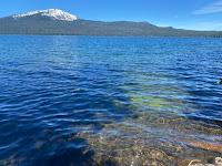
Crater Lake National Park, photo by Yeny Mancia

As you approach Crater Lake National Park many campgrounds await, though you must make sure to have made your reservation months ahead of time. To the north and along the edge of Diamond Lake are three campgrounds: Broken Arrow, Thielsen View and Diamond Lake. To the west and southwest,  along highway 62 you’ll find campgrounds along the creeks that feed into the Rogue River: Mill Creek, River Bridge, Natural Bridge, Abbott Creek and Union Creek Campgrounds. The park itself has two campgrounds. The true magic of this entire area lies in its creeks, rivers, lakes and waterfalls, but be prepared for mosquitos and bugs by bringing bug spray. 

We camped at Diamond Lake campground and had lakeside views. Along this campground, various activities are available for you. Rent paddle boats, fishing boats, or kayaks to explore the lake. An easy and mostly flat bicycle road follows the lake’s edge, making it a tranquil ride within the forest. The campground store offers freshly made pizza, decadent ice cream and handcrafted sandwiches.


The Crater: Awe-Inspiring Views Await

Crater Lake National Park, photo by Yeny Mancia

Once at Crater Lake prepare to be spellbound by the wonders of its rim. Every side of its rim has awesome panorama views of Mt Shasta and the Klamath Mountains that add to the magic of the place. Along the road are waterfalls that are very cold for you to cool off and dip your feet in, but be sure to wear sunscreen because the sun is intense. 

Taking a short hike to the crater’s rim rewards you with breathtaking views of Wizard Island set against the deep blue waters. Hiking down to the water's edge gives you a chance of diving into the cold waters and is highly recommended. Once you come out of the water you will feel refreshed. If you decide to take a dive make sure to open your eyes to see the mesmerizing blue glow that envelops you.


Exploration and Wonder: An Adventure Worthwhile

You can spend more than one day hiking and backpacking around the crater that range from easy to strenuous. When we were there the southeastern section of the lake was closed for road repairs, so try to get as much information on road conditions as you enter the park. The visitor center has a cafeteria offering fast food options like sandwiches, hotdogs, and chicken tenders. We bought some chicken tenders, along with some cold drinks and had lunch under the shade of some majestic pine trees.

Meeting a park ranger you’ll learn more about the park’s history. Crater Lake was once a 12,000 foot tall volcano named Mount Mazama by scientists today. Its eruption cut away a mile’s worth of height from its top which made it the caldera we call Crater Lake. From a distance, snow-covered volcanoes like Mt. Shasta stand in silent majesty on the California side.


Conclusion: Embrace the Magical Mystery

Crater Lake National Park is a place that has an amazing geologic history with an environment that is perfect to enjoy in the Summers. The drives through the surrounding forest and edge of the caldera make a visit here worthwhile. Whether you bring your family, gather your friends, or set off on a solo escape, Crater Lake’s magic awaits- an adventure well worth embracing.

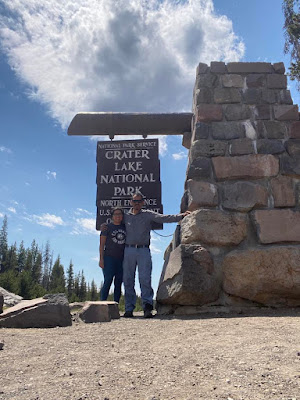
Crater Lake National Park, photo by Yeny Mancia


Sunday, August 7, 2022

Antelope Valley California Poppy Reserve: Road Trips from Los Angeles


Antelope Valley California Poppy Reserve: A Day Trip
by Armando Ortiz

   I've been to the Antelope Valley California Poppy Reserve State Natural Reserve many times, especially during Spring. The drive to this place is great and you have two options. Both ways of getting there from L.A. will take you through landscapes a bit different than the usual LA sights. You will be driving through the eastern edge of the Simi Hills and the western end of the Angeles National Forest mountains. 

First option to get there is via Highway 14 north, by taking the Interstate 5 north, then once you’ve passed San Fernando Valley you get on the 14 north all the way to Lancaster where you will exit Avenue I. Next, you will make a left and stay on that street till you join Lancaster Road. This route is the fastest and the most direct and you mostly get to see the western end of the Angeles Crest mountains. As you are driving north you can enjoy looking at the slanted rock formations that can be seen to the left-  Vasquez Rocks, whose name is taken from L.A.’s historic bandit - Tiburcio Vasquez.

The second option is a bit slower but the drive too is scenic and different. From L.A. you take Interstate 5 north and drive to the Magic Mountain area. You exit on Newhall Ranch, make a quick right, and drive past the rodeo grounds that will be on your right side. Then you will make a left on Copper Hill Drive and drive till you reach San Francisquito Canyon Road. Here you will make a left and head north for about 15 to 20 minutes, here you see drive through canyons, oak groves and see lingering signs of ranch life, till you merge with Elizabeth Lake Road, where you will make a left, and soon you will reach Munz Ranch Road where you will turn right. Depending on the year's rain and your time of visit, the hills in these areas might be splashed with the colors of wild desert flowers. The road winds its way through rolling grassy hills that will be peppered with tangerine colors, purple lupines and varying yellow hues. 

You pay to enter the Poppy Reserve and it is well worth the price. In the reserve there are picnic benches near the front, but you can also take a break in your car. There are defined trails that are easy to walk on. There might be one or two sections throughout the site that might get intense for a few meters. There is also a visitor center where you can purchase the typical souvenirs found in such places. It's worth going inside and checking out unique things related to the high desert, like books and hats. If you do decide to hike one of the trails make sure to take some water and a lunch. There are benches along the trails where you can sit and enjoy the views and reach into your bag and enjoy a snack. For a moment you can be transported to the past, when these flowers carpeted not only this area, but extended and covered all of the high desert and even all of Los Angeles. 

If you are on a budget you can pull off the main road where there is a decent amount of blossoms and enjoy the sights. Sometimes parking along the road can be intense, because many people visit this section of Los Anglees during the Spring, especially when there has been plenty of rain. Nevertheless, remind yourself that you are there too see a Spring blooms, and that’s what others are doing too, and believe it or not many people in the city ever drive this far to see something so unique.There are off road trails where you can enjoy the poppy fields, but you have to make sure your car is capable of doing light off-roading as well.

The best time to visit is during the Spring. Timing your visit will depend on how well you keep track of the rainfall in the deserts. Usually if it has been a wet year in Los Angeles you can rest assured that there will be poppies blooming in spring. It is all a matter of monitoring the rain fall, and also the weather because just as it can be a rainy season, hot weather the next week can mean that there will be a short blooming season. In addition, poppies are one of many wildflowers that bloom during the Spring, and these blooms can come in waves. Meaning, before poppies blossom there might be a blooming of desert lupines, goldfields, painted brush, and many others.


Saturday, December 9, 2017

Montana De Oro State Park: Road Trips from Los Angeles

Morro Bay at a distance
Camping in California: Montana De Oro State Park
By Armando Ortiz
Watching the sun go down.
I drove through the area where this campsite is located a few years ago. It was past midnight and I was coming from Nor. Cal., the sky was onyx, and the moon’s light reflected on the coastal waters, like an old Mayan carving made of obsidian. At times I could see the white of the ocean water that was crashing onto the coastal crags. The tree groves seemed to just grow wild along the side of the road. This time around I came here to camp and to do some hiking.
Montana de Oro State Park is a very beautiful park that has lots to offer to any visitor. This park is located along the coast of Los Osos, which is about ten to fifteen miles west of San Luis Obispo. Along the way to the park one can find convenient stores and grocery stores where you can stock up on goods. The park gets heavily visited by day hikers, college students and people that are into outdoor sports.
My camp at Montana De Oro
I camped on the Environmental Site 1. Finding parking lot where I had to leave my car was not difficult, but the spot where I’d set up my tent was initially tough to find, but eventually I did. Initially I was a bit unsure of the location where I’d be staying for the night. My site was a quarter of a mile away from my car, and I seemed to be unprepared for a hike. After setting camp, and relaxing I discovered that there was a trail to hike right next to my location. In addition, the coastal sand bluffs were a few minutes away walking. I’d never been or seen such a place. The sand bluffs were new to me. I’d never been to coastal dunes, which make for some majestic photos.
Wild buck at a distance
As I climbed a dune I saw a wild buck. I tried getting closer, but still keeping a fairly good distance from it and took some photos of the wild deer. After having a light snack, and seeing the sun set, I began making my way back hiking around some more and once the sky began to darken returned to camp.During the night coyote visited me, it was outside the tent, all I could see what the shadow that its body created after I turned on the lamp. The rustling eucalyptus trees had woken me up as the midnight wind blew. Nights speckled with shinny pearls and owls watched my every move. Throughout the night coastal waves said, everything would be alright.
Morning at Montana De Oro State Park
In the morning I had instant oatmeal with a packet of trail mix. The tweet of fly catcher families greeted my morning walk.  As I headed towards to my car I saw butterflies float bye. They seemed to be following the northeastern sun. They seemed to be fluttering their wings, like black eyelashes on mocha skin. They moved gently, as if following the push of the breaking wind.

While I hiked the cliffs, a Condor glided bye and followed the edge of sand cliffs. I couldn’t help to imagine an aged cuirass protecting a soldier from an old armada galleon setting foot on the coast. Climbing these sand dunes for god and glory and finding maidens sitting, watching the sun go down. The smell of wild sage and sweet blossoms mixing with the desperate sweat of danger and opportunity, for a moment a flash crossed my mind.

Sunday, December 3, 2017

Leo Carrillo State Park: Road Trips from Los Angeles

The sun sets at Leo Carrillo beach.
Camping in CaliforniaLeo Carrillo State Park
 By Armando Ortiz
Camp site 59, at Leo Carrillo State Park.
Its Thanksgiving break, the weather is cooler, and during this time Angelinos tend stay indoors. So I decided to see if there were any campsites available. I logged on to the California state parks website and found site 59, which was available for the night.
            Leo Carrillo State Park is at the edge of Malibu, so it took about an hour to get to the park when coming from Los Angeles. Right before arriving I stopped by the Pavilions up the road and bought lunch and dinner. I arrived at the park, checked in and went to my spot. Lots of squirrels scattered as I got out of my car, and scanned the area. I sat on the wooden bench and ate my lunch. Then I set up my camp, and went for a walk. The sites to the left and right of me were empty though online it appeared that they’d been reserved.
Leo Carrillo tide-pools.
            The state park is filled with old California oaks, making the walk to the beach a pleasant one, which took about 10 minutes. The sun was setting, and rocks jutted out of the beach creating a large area of tide pools. A few minutes later I headed north, trudging through the sand, and sat on top of a cliff and saw the sun set.
            At night the neighbors across from my camp were loud; a lady’s laugh sounded like a scandalous parrot, and didn’t stop talking till around 11pm. People shatter doesn’t compare to the sound of cars speeding up the road that borders the park. Mullholland Highway is next to the park.

            Overall, this is a nice place to visit and camp. It seems more family oriented than other campsites, since there are tide-pools and beaches, being very kid friendly. To wrap things up, I highly recommended for families and for a nice romantic outing with that special someone. I imagine that in the summer nights are long and the park is always filled to the brim.
California oak at Leo Carrillo State Park.